
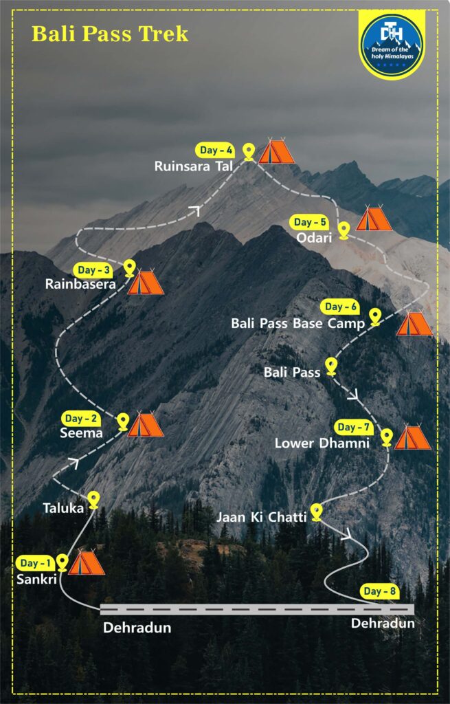
Bali Pass Trek
Starts @ ₹ 22,000/P (8D-7N)
Overview :
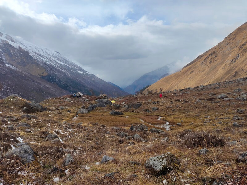
The Bali pass trek is not recommended for first-time hikers since it is really challenging and you need to have a high level of fitness if you want to accomplish the whole thing. As the Bali pass trek requires trekking at high elevations, it is not recommended for anyone who have respiratory issues or who have had altitude sickness in the past. During the course of the hike, you will most likely be accompanied by an incredible group of other adventurers, and we at Holyhimalaya guarantee that you will reach the bottom of the mountain together with the intention of climbing further peaks in the near future. The months of September and October are ideal for making an effort at completing this trek. This assures that the difficulty level will decrease somewhat as there will be less snow, which will unblock your paths, and there will be no rain, which will ultimately prevent the slippery terrains from occurring. Now, trekkers who are looking to advance to the next level have the option of going during the pre-monsoon seasons as well. The treacherous terrain and sweltering heat will ensure that the journey is full of excitement and suspense from start to finish. The journey over the mountain range on foot starts in a settlement known as Sankri. Arriving at Dehradun, which is the state capital of Uttarakhand, is required before continuing on to Sankri. From Dehradun, the journey to the Sankri village is around 197.2 km long and takes between 6-7 hours. The first location of significance is the Debshu Bugyal, which provides breathtaking panoramas of the Kalanag Mountains. The much-anticipated stop at the Bali pass base camp is a very short but difficult one since it occurs after the 15,000-foot threshold is passed. Lower Dhammi through Bali pass is the location of the last camping spot. The journey will take place in deep snow. On the last day of the hike, we will make the ascent all the way up to Yamunotri, which is the starting point for the pilgrim trail that leads to Jaan Ki Chatti. The participants will take with them some memories that will last a lifetime when they go to Dehradun the day after the event.
Keypoints:
- Base camp: Sankri
- Grade: Moderate to Difficult
- Months: May to June and September to October
- Height: 16,200 Ft.
- Distance: 55 Kms
- Pickup/drop: Dehradun to Dehradun
ITINERARY :
From Dehradun, the distance to Sankri is 197.2 km, which would take you about 6-7 hours to go by car. You will go through the National Park, which is home to a diverse assortment of plant and animal life, at some point throughout the voyage. You won’t have time to feel exhausted since you’ll be too busy being fascinated by this. It is imperative that you stay alert and prevent yourself from falling asleep when travelling to the Sankri settlement. As soon as you get in Sankri, you will be given accommodations at the guesthouse that is located there. After the long and exhausting travel, you should rejuvenate yourself by learning about the customs and traditions of the area. After indulging in the regional specialties, make your way back to the guest home to settle down for the night.
Travel from Sankri to Taluka in the early hours of the morning. The trip should take around one hour. After a fantastic breakfast, which will be provided for you at Taluka, we will then set off on foot in the direction of the Seema Camp. Along the path, you will pass through many thick woods that are filled with chestnut trees, willow trees, and fir trees. In addition to that, you will see several beautiful waterfalls that stream down the mountainside. The path is uncomplicated and completely even. The path then splits in two further on, and we have the option of taking the steeper and shorter ascent that goes through the settlement of Dhatmeer or the one that goes beside the Karmanasha stream. You will arrive at the hamlet of Gangaar regardless of which path you choose. Continue your ascent to the Seema campground. You will initially set up your tents at this location, which is the starting point of the hike. After you have finished eating your meal under the stars, we will set up tents for you to sleep in for the night. Depending on the temperature and the humidity, we will plan several enjoyable activities.
After a fantastic breakfast the next morning, our journey down the Supin river continues in the same direction. Our initial trek across the pass is called Debshu Bugyal, and up ahead in the valley, the towering Kalanag can be seen. The answer to your climb will be found in the beautiful sights that Kalanag has to offer. Camping in Debshu Bugyal is an experience in natural splendour. with the month of September, the verdant green meadow will be covered with a carpet of small flowers that are in bloom, each of which will have a dazzlingly different colour. The lush green meadow will be encircled by flowering Rhododendrons throughout the months of April and May. It is also a wonderful location to observe the local avian life. There are also a few birds that you could see, such as the Red-billed Blue Magpie, the Blue Whistling Thrush, Rosefinches, and a great deal of other species. The pathway goes downhill, and the surface of the path is made up of loose gravel and sand. Then, after we’ve over the bridge that stretches across the Supin river. After this point, the path continues to climb, and the Supin River can now be seen flowing to the right. There are still some challenging passages up front of us before we get to the campground at last. Tents will be set up for dinner and sleeping accommodations for the night. You may see the Milky Way stretching over the whole horizon when you look up in the night sky. This is a beautiful sight to see.
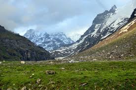
The route eventually ascends into the Ruinsara valley, during which time it becomes disconnected from the Supin river. The imposing summit of Ruinsara gradually comes into view. Soon, we will be nearing the elevation of 3,400 metres (11,000 feet), and we will soon be to the Ruinsara Tal or the glacier lake. The glacial lake is encircled on all sides by interminable meadows and bushes of rhododendron. You will have the opportunity to practise your photography skills here. Instead of sleeping in tents, you will spend the night in rustic wooden cottages. The campground provides guests with some breathtaking views of the natural splendour of the area. Both the south-west and the east provide access to Yamuna Kanta, while the east provides access to the great Mt. Bandarpoonch, which towers above all of its splendour at an altitude of 21,000 feet. Here, you can also make see Kalanag and White Peak in the distance. After you have finished eating your meal under the stars, we will set up tents for you to sleep in for the night. Take in all of the splendour that surrounds you. It is my goal that you will have sufficient time to recuperate and get yourself prepared for the new difficulties that will present themselves during the next several days.
Getting to Odari is going to be the primary focus of the next day. The walk is not too difficult and is not too long. The distance is not very challenging; the main challenge comes from the large elevation climb. We make our way down through the dense woodlands that surround the Supin river, and then we cross it on a bridge. Along the river, we are going to keep moving in a south-easterly direction. After a short journey of a few km, we go in the direction of the south-west. The lush vegetation will soon give way to a rough and rocky landscape, which will lead us to Odari, the location of our next camping spot. The sun is at its peak intensity in the early part of the summer. While snowshoeing, it is important to wear sunglasses that provide protection from UV rays in order to keep your eyes healthy. An old rock cave known as Odari is supposed to have had a role in the Hindu epic known as the Ramayana. You will get a deeper understanding of the history as well as the culture of India, in addition to learning more about the history of Ramayana and Bali. In the evening, we will have a practise session during which a couple of strategies will be presented to you. These strategies will be of assistance to you as you go forward in the following couple of days. The day will come to a close when everyone retires to their tents for the night.
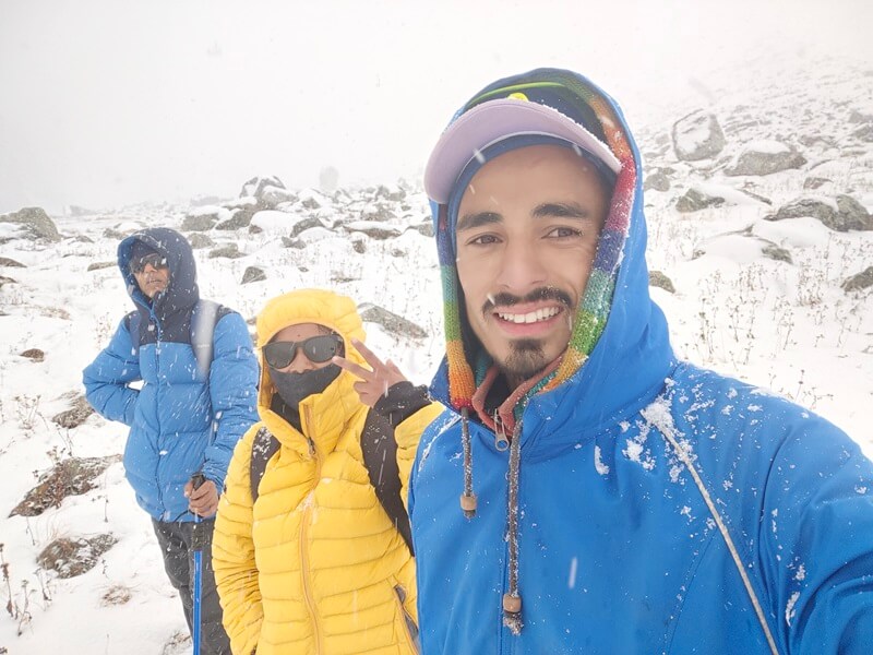
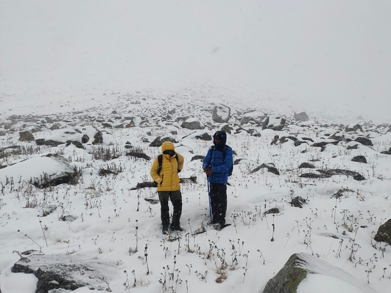
The journey continues in the direction of the base camp for the Bali Pass. Along the journey, you have to scale a number of hills, which is a task that is very difficult and nerve-wracking. The ridges have a similar acuteness and incline to that of a knife’s blade. Glaciers covering one side of the ridge, as well as rock debris on the other side. It’s possible that the first ridge will seem like a big issue. You need to keep the regulations of the walk in mind and make sure you’re following our recommendations correctly. The steep ridges have an angle of between sixty and seventy degrees. You need to have your leader in sight at all times and proceed with cautious, tiny steps. You may also use your ice axe to fend off the snow by keeping it at bay. The trip will give you the opportunity to see the immensity and emptiness of the pass, which is encircled entirely by a cloudy sea. The hike is not very long, but in order to prevent acute mountain sickness (AMS), it is important to stay active and drink enough of water. When we reach an altitude of 15,000 feet on our hike, the temperatures begin to drop significantly. Additionally, there is a possibility that it could snow, which will make the journey more difficult. You are going to get the shivers from the chilly breezes. In order to protect oneself from being sick in any way, you should dress in layers using appropriate attire. Following the meal, we get a head start on getting ready for the adventure the next day.
The beginning of the breathtaking dawn, which will occur so quickly that it will leave you puzzled for a minute, will occur quite early in the morning. We proceed in the direction of traversing the Bali pass so that we may arrive at our last camping spot. The day starts out at a relatively early hour. Following breakfast, we will continue our walk into the snowfields. In order to make greater progress, we shall use strategies using ice and rock. You won’t need to worry about a thing with our journey guides looking out for you. The ascent is difficult due to the steepness of the segment. The bone-chilling weather and the snow pathways provide a challenge but, at the same time, offers an exciting opportunity. We are afforded the opportunity to take in the breathtaking vistas that the nearby peaks have to offer. There are points along the trail when passage is reduced to a width of less than 6 inches. When we reach Upper Dhamni, we stop for a while to recuperate before continuing on our journey. After a bit, we get our hiking boots on and go in the direction of Lower Dhamni. The Lower Dhamni is a peculiarly wooded region that is characterised by steep hills. Tents are provided for the night’s lodging.
The journey’s last day has finally arrived. You have the option of rising early in the morning to take in the crisp air for the last time, taking some photographs to serve as a reminder of the experience, and watching the dawn from the campground for the very last time. As this is the last day of the walk, you will each have breakfast, and there will be some activities that you will participate in as a group. The path then carries on for another hour through a verdant forest before emerging onto a paved path that leads all the way up to Yamunotri. This path is the last leg of the journey. Here, you will get the opportunity to pay a visit to the well-known Yamunotri Shrine. You may also wash away your fatigue by taking a revitalising swim in one of Yamunotri’s steaming hot water springs. These springs are located towards the summit of the mountain. We go farther down the winding Yamuna River and follow the pilgrims’ path to Jaan Ki Chatti, a little village that is always bustling with activity. Here, we spend the night in a guest home. The next day, you will begin the journey back to Dehradun, which will signify the conclusion of your incredible expedition.
Inclusion & Exclusion
- Tented twin/triple sharing stay throughout the trekking journey.
- Vegetarian meals along with eggs, will be served.
- Sleeping bags, Tents, Thick mattress, separate kitchen, Dining tent, Crampon, Gaiters & Utensils.
- Professional Local Guide
- All Permits
- Transportation as per itinerary from Day 1 to last day
- Transportation to/from hometown to Itinerary’s Day 1 and last day location.
- Personal expenses
- Emergency evacuation cost.
- Porter to carry personal luggage will be charged extra.
- 5 % GST
- Insurance
Things to Carry
- A trekking bag of minimum 20ltr capacity
- A good quality water bottle for your entire trekking journey (like- Borosil, Milton etc).
- Sleeves and waterproof gloves.
- 2 trek pants and cargo pants are suggested to keep with you. 4 pairs of warm socks, A small towel, a poncho.
- Good quality waterproof shoes above the ankle length are preferable.
- Personal Medical Kit containing all types of medicines and first aid things.
- Toothbrush and paste for your mouth hygiene
- 2-3 packs of Paper soap and 1 bottle of sanitizer
- Sunscreen, lip balm, cold creams, Body spray to prevent you from direct sunlight.
- LED torch light for an emergency purpose at night or summit attempt.
- Power bank with minimum of 20,000Mah battery backup to charge your phone during the journey for capturing happy moments.
- Sunglasses for your eyes protection and Woollen cap for your head and ears protection
FAQ's
After arriving in Dehradun, drive to Sankari through the scenic surroundings of Mussorrie and the stunning Yamuna River; stop for lunch along the way. The breathtaking pine forests, snow-capped peaks, and scenic views will keep you entertained and excited throughout this long journey of 8 hours.
After arriving in Dehradun, drive to Sankari through the scenic surroundings of Mussorrie and the stunning Yamuna River; stop for lunch along the way. The breathtaking pine forests, snow-capped peaks, and scenic views will keep you entertained and excited throughout this long journey of 8 hours.
After arriving in Dehradun, drive to Sankari through the scenic surroundings of Mussorrie and the stunning Yamuna River; stop for lunch along the way. The breathtaking pine forests, snow-capped peaks, and scenic views will keep you entertained and excited throughout this long journey of 8 hours.
After arriving in Dehradun, drive to Sankari through the scenic surroundings of Mussorrie and the stunning Yamuna River; stop for lunch along the way. The breathtaking pine forests, snow-capped peaks, and scenic views will keep you entertained and excited throughout this long journey of 8 hours.
After arriving in Dehradun, drive to Sankari through the scenic surroundings of Mussorrie and the stunning Yamuna River; stop for lunch along the way. The breathtaking pine forests, snow-capped peaks, and scenic views will keep you entertained and excited throughout this long journey of 8 hours.
Trek Map


