
Rupin Pass Trek
Starts @ ₹ 17,500/P (8D-7N)
Overview :
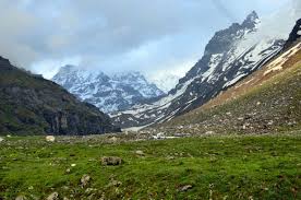
Rupin Pass is best described as a cross-country walk that is full of twists and turns, each of which brings a new experience and new views of the surrounding landscape. This high altitude trek is a favourite among those who are looking for an exciting new experience since it is regarded as one of the top trekking routes in all of India. This hiking trail is located at an altitude of 4,700 metres (15,350 feet), and it traverses two distinct states in India. Along the way, it offers some stunning sights and takes hikers past several interesting natural features. The Rupin Pass trek begins in Dhaula, which is located in Uttarakhand, and concludes in Sangla, which is located in Himachal Pradesh. The attractiveness of the trek route resides in the fact that it provides participants with the opportunity to see not only the deserted snow-covered Himalayan area but also the two extremely unique local cultures of the two states that are next to one another. This high altitude hiking adventure through Rupin Pass provides you with a wealth of variety in all of its guises. During the course of the walk, you will traverse a wide variety of terrain, some of which may change suddenly. You may find everything on one walk, from snow-covered fields to rocky terrain, from lush green meadows to deep folds in the mountain, from glaciers, snow bridges, and icy slopes to habitations and holy places.
Keypoints:
- Base camp: Shimla
- Grade: Moderate to Difficult
- Months: April to June and September to November
- Height: 15,200 Ft.
- Distance: 50 Kms
- Pickup/drop: Dehradun to Shimla
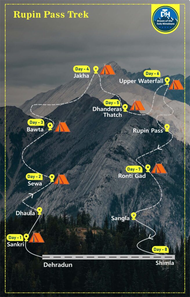
ITINERARY :
Drive to Sankri via Mussoorie, which is 220 km away. Visit the Kempty Falls, which are located 15 km away from Mussoorie. Continue the trip in the direction of Purola, which is situated at an elevation of 1,524 metres. It is also known as the “Gate to Har Ki Dun” because of its location in the midst of a dense woodland region that is home to a variety of species, most notably the endangered snow leopard. Spend the night in the rest house or the tent provided in Sankri.
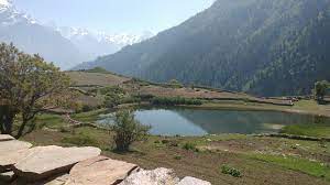
After breakfast, make your way to Dhaula, which is a 26-kilometer off-road journey that should take around one hour to complete. The trek will begin at Dhaula, but it won’t be a particularly taxing experience for you since the whole journey is a simple trek through gently sloping roads all the way to Sewa. Visit the well-known Kinnaur Temple in Sewa, where the villagers have proudly displayed their medals and trophies won in competitions both within and outside the temple. When you arrive at Sewa, you will feel a little bit of disappointment since the views are not quite as appealing as they were in the past. However, you have the option of either camping at the designated site outside of Sewa or staying inside Sewa Village itself. You will be camping among rocks, which will undoubtedly give you the impression that you are staying on the beach.
The level of difficulty of today’s trek gradually goes from moderate to severe. Because the surrounding terrain is prone to landslides, and the path itself has regular variations, our crew will educate you throughout the day. This is necessary due to the high degree of difficulty. Following three hours of very easy walking, there will be a one-hour stretch of more strenuous climbing. Your journey begins out in a field with a variety of crops and then abruptly enters a jungle. After making your way through the dense forest, you will eventually come to an area close to a wooden bridge that spans the river that divides the two states. The name “No man’s Place” was given to the bridge since it is in the middle of nowhere and does not belong to any state. After Raj Gad, the route has a sharp rise all the way to Bawta. Take pleasure in the cool shade provided by the Deodar and Walnut trees as you stroll. After the strenuous journey, you will be able to relax in tents.
You will have to traverse a variety of topographic elements today as you make your way up a moderately steep trail until you reach Jiskun, where you will then begin a little descent. The trek is around 5 km long and it terminates in Jhaka, which is where you will set up tent for the night. As you continue further, you will get a glimpse of the Selwan Khad, which is a place where you may replenish your water bottles. As you get closer to Jiskun and the degree of difficulty of the walk is modest, it would be a wonderful delight to enjoy the calming weather and indulge in some snacks with tea as you make your way there. You will reach an elevation of around 9,000 feet after completing this portion of the trek, which takes about four hours to complete.
Today you will do a fulfilling trek of 11 km that will take around 8 hours. You get up before dawn and go out on foot from the Jhaka campground you’ve been staying at in order to get to the Dhanderas Thatch area. You will be given guidance on how to have a good journey day with the least amount of difficulty possible since the path that you will be trekking today is a little bit challenging. The walk we have planned for today is in every way an interesting and adventurous one. When you are trekking, it is imperative that you exercise extreme caution since the terrain may be treacherous, as it is both slick and prone to landslides. As you make your way out of Jhaka, you will first pass through fields of different crops before entering a thick, dark forest. The shifting of the plants is fascinating and adds a touch of excitement to the experience. You will eventually reach a wooden bridge after making your way through the forest and hopping over the many brooks, rivers, and streams that you encounter along the way. Following a short distance of trek in this direction, you will begin your difficult climb to Saruwas Thatch, passing through the lush mountain flora consisting of Deodar and Walnut trees. When you have completed your day’s worth of trekking by making a slow descent to Dhandarus Thatch, you will have arrived at your destination, where you will spend the night in tents.
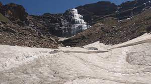
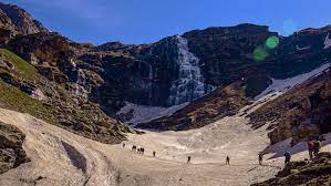
In today’s trek journey, you will trek a distance of 5 kilometres. The trek today will get you to an elevation of 13,300 feet in around 4 hours. Having said that, you will have to climb until you reach the higher waterfall, after which you will be left wondering how a route like this was carved out of the rock face. As a result of the dramatic changes in both the route topography and the surrounding environment, the ascent to Upper waterfall is not only fun but also highly intriguing. You begin your trek through the mixed thick forest on a track that zigs and zags over the terrain. On the other side of the forest is a cliff. It is imperative that you have the appropriate acclimation and preparation for today.
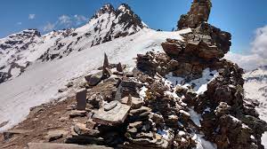
On the path leading up to Rupin Pass, this will be the most lengthy and perhaps the most difficult section. You will go to an altitude of 15,400 feet from 13,100 feet, and then you will have a precipitous plunge down to 13,100 feet from that point. It is highly recommended that you replenish your water bottles at the Rati Pheri campground given the restricted availability of water sources. Starting from Upper waterfall, you will have to climb steeply for an hour in order to reach Rati Pheri Campsite. This will be your destination. At this location, all that you would be able to see is snow spread out over the landscape in all directions. To get to the gully at Rupin Pass, you would have to go across these icy passages. However, traversing the limitless snow fields while keeping an eye out for Rupin Pass in the distance might prove to be a task that is not only difficult but also exciting. Walking on snow may need you to take appropriate measures since there are no well-defined paths in this area, and slipping and sliding are extremely prevalent in snowy environments. A strong awareness of one’s surroundings is also essential. From Rupin pass, the journey to Ronti Gad would begin with an easy stroll and end with a steep descent.
Today is the last day of your trek. Decend down towards Sangla. After you have arrived in Sangla, those of you who have further plans may say your goodbyes to the group, obtain your trek certificate, and go on your way with a wealth of memories and the desire to face another challenge very soon. Those of you who have already made travel arrangements with us may get in the taxi/traveller to begin the nine to ten hour journey from Sangla to Shimla.
Inclusion & Exclusion
- Tented twin/triple sharing stay throughout the trekking journey.
- Vegetarian meals along with eggs, will be served.
- Sleeping bags, Tents, Thick mattress, separate kitchen, Dining tent, Crampon, Gaiters & Utensils.
- Professional Local Guide
- All Permits
- Transportation as per itinerary from Day 1 to last day
- Transportation to/from hometown to Itinerary’s Day 1 and last day location.
- Personal expenses
- Emergency evacuation cost.
- Porter to carry personal luggage will be charged extra.
- 5 % GST
- Insurance
Things to Carry
- A trekking bag of minimum 20ltr capacity
- A good quality water bottle for your entire trekking journey (like- Borosil, Milton etc).
- Sleeves and waterproof gloves.
- 2 trek pants and cargo pants are suggested to keep with you. 4 pairs of warm socks, A small towel, a poncho.
- Good quality waterproof shoes above the ankle length are preferable.
- Personal Medical Kit containing all types of medicines and first aid things.
- Toothbrush and paste for your mouth hygiene
- 2-3 packs of Paper soap and 1 bottle of sanitizer
- Sunscreen, lip balm, cold creams, Body spray to prevent you from direct sunlight.
- LED torch light for an emergency purpose at night or summit attempt.
- Power bank with minimum of 20,000Mah battery backup to charge your phone during the journey for capturing happy moments.
- Sunglasses for your eyes protection and Woollen cap for your head and ears protection
FAQ's
After arriving in Dehradun, drive to Sankari through the scenic surroundings of Mussorrie and the stunning Yamuna River; stop for lunch along the way. The breathtaking pine forests, snow-capped peaks, and scenic views will keep you entertained and excited throughout this long journey of 8 hours.
After arriving in Dehradun, drive to Sankari through the scenic surroundings of Mussorrie and the stunning Yamuna River; stop for lunch along the way. The breathtaking pine forests, snow-capped peaks, and scenic views will keep you entertained and excited throughout this long journey of 8 hours.
After arriving in Dehradun, drive to Sankari through the scenic surroundings of Mussorrie and the stunning Yamuna River; stop for lunch along the way. The breathtaking pine forests, snow-capped peaks, and scenic views will keep you entertained and excited throughout this long journey of 8 hours.
After arriving in Dehradun, drive to Sankari through the scenic surroundings of Mussorrie and the stunning Yamuna River; stop for lunch along the way. The breathtaking pine forests, snow-capped peaks, and scenic views will keep you entertained and excited throughout this long journey of 8 hours.
After arriving in Dehradun, drive to Sankari through the scenic surroundings of Mussorrie and the stunning Yamuna River; stop for lunch along the way. The breathtaking pine forests, snow-capped peaks, and scenic views will keep you entertained and excited throughout this long journey of 8 hours.
Trek Map


